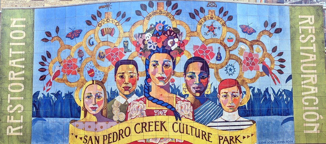
Above: “Restoration,” mural by Kathy and Lionel Sosa
Once upon a time, I logged a lot of hours at City Hall, sometimes parking on a surface lot behind it. Behind it meaning on the other side of an unrecognizable creek. An ugly footbridge, hemmed in by chained-link fencing, crossed a narrow trash-filled concrete-walled ditch – San Pedro Creek. A place creepy enough to leave me feeling I should pay an extra dollar or two to park in front of City Hall.
In this place of herons where the grasses sway in starlight I have flowed since the dawn of evermore.
John Phillip Santos, historical text carved in limestone
The stretch of San Pedro Creek between the tunnel inlet at I-35 and Houston Street beside a new office tower climbing toward the sky might only be a little more than four blocks long, but the transformation from drainage ditch to park seems miraculous to me.
Yes, I watched the earlier magic worked on the Museum and Mission Reaches of the San Antonio River Improvements Project, but there was absolutely nothing natural-creek-like remaining following decades of flood-control projects in this neighborhood.
Some dismiss projects like these as “legacy projects” fluffing up politicians’ egos with taxpayers’ dollars. Politically charged, the design process for a project this complex is rarely perfect. There are budget cuts, and still the enormous projects tend to run over-budget.
But, as with the original Paseo del Rio project, they can prove visionary. Development along the Museum Reach demonstrates how quickly highly blemished urban corridors become desirable.
John Phillip Santos historical text
Adriana M. Garcia “De Todos Caminos Somos Todos Uno”
Diana Kersey “Bridges of Understanding”
Joe Lopez “Bellos Recuerdos del Teatro Alameda y Tiempos Pasados”
Diana Kersey “Bridges of Understanding”
John Phillip Santos historical text
Joe Lopez “Bellos Recuerdos del Teatro Alameda y Tiempos Pasados”
Adriana M. Garcia “De Todos Caminos Somos Todos Uno”
Adriana M. Garcia “De Todos Caminos Somos Todos Uno”
Diana Kersey “Bridges of Understanding”
Diana Kersey “Bridges of Understanding”
“Rain from the Heavens”
Joe Lopez “Bellos Recuerdos del Teatro Alameda y Tiempos Pasados”
Katie Pell “Red Arch, Green Arch”
John Phillip Santos historical text
John Phillip Santos historical text
Diana Kersey “Bridges of Understanding”
new Frost Bank Tower
Adriana M. Garcia “De Todos Caminos Somos Todos Uno”
While flood-control is an underlying purpose of the San Pedro Creek Improvements Project, the incorporation of site-specific art reflective of the city’s history and culture gives the new pedestrian passageway a distinctive San Antonio feel.
Bexar County is the primary funder of San Pedro Creek Culture Park, and the San Antonio River Authority is project manager.
looking south from Houston Street
Work is underway on the next phase heading southward from Houston Street. As you can see from the photo, this narrow stretch probably is even more challenging.
In my mind, the photos above illustrate that the complications and difficulties encountered along the way are so worth it. Those involved are leaving a legacy that will enrich the quality of urban life for generations to come. Looking forward to walking the next phase and those to come.
Colonel George W. Brackenridge, one of our oldest, wealthiest and most prominent and respected citizens, has tendered to the city a handsome gift in the form of a 200-acre tract of land near the head of the river, to be dedicated to the use of a public park. Colonel Brackenridge acquired the property some twenty years ago, but beyond enclosing it with a wire fence, has never improved it.
The tract is heavily wooded and susceptible, at considerable outlay, of being transformed into a beautiful and inviting “breathing spot.” Not unnaturally, Col. Brackenridge has been the recipient of many complimentary utterances….
San Antonio Light, November 12, 1899, page 2
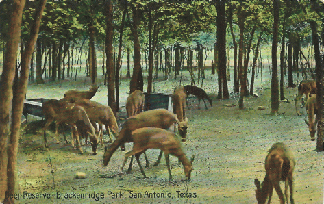
In Brackenridge Park, San Antonio has one of those places nature made beautiful. Its two hundred odd acres are wild and picturesque, a primeval forest which has not been spoiled by the hand of man…. you will find a beautiful natural woodland with winding driveways overarched with splendid live oak trees festooned with hanging moss. Here in captivity live elk and deer and buffalo. Here the squirrels chatter at play, and the wild beauty of this spot makes it one of the most attractive parks in America. San Antonio, Chamber of Commerce Booklet, 1909
Well past her century mark, it is not surprising that Brackenridge Park is overdue for a facelift. Recognizing this, San Antonio City Council unanimously approved a master plan for the park on March 2, and approval of funds via the upcoming bond election on May 6 will jumpstart the plan’s implementation.
A day-long summit presented by the Cultural Landscape Foundation and Brackenridge Park Conservancy on March 3 represented a thoughtful approach to the ongoing planning process for the park. Panels focused on what could be learned from other recent improvement projects in San Antonio as well as park projects in other cities.
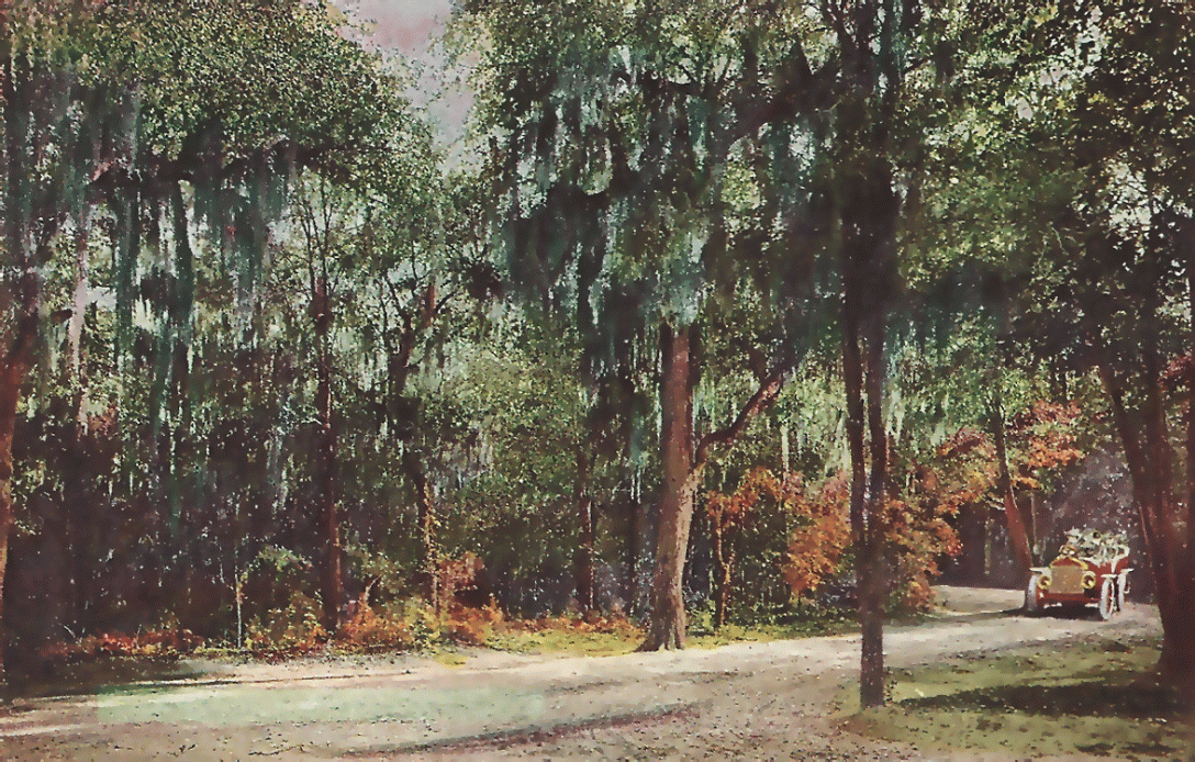
Kinder Baumgardner, managing principal of SWA in Houston, pointed out that the beauty of Brackenridge Park often was spotlighted on postcards visitors would purchase to send home. But, he posed, “Is it still a postcard place?”
Of course, once home, that sent me scrambling though my folder to look, because, as you can tell by the masthead of my blog, I like old postcards.
Charles Birnbaum of the Cultural Landscape Foundation recognized the Japanese Tea Garden as the first quarry in the United States to be transformed into a garden.
As an introduction to the first session, Charles A. Birnbaum, president and CEO of the Cultural Landscape Foundation, pointed out that some of this “vacant” space has been plagued by a “plop and drop” approach to developing the parkland without enough planning focused on the importance of visual and spatial relationships. He stressed that “edge matters.” The park needs to be without borders, “porous.”
Speaker after speaker echoed this. Andres Andujar, CEO of Hemisfair Park Area Redevelopment Corporation, noted the importance of “connectivity and porosity.” As the park is hemmed in by its neighbors and proximity to Highway 281, Douglas Reed, principal of Reed Hilderbrand, was among those looking eastward to create connections. The edges of Brackenridge Park should be opened up from Broadway.
Opening up the parkland is a major planning challenge facing the Brackenridge Park Conservancy because the blockage originated at the time of the original gift. The 1899 article about Brackenridge’s gift quoted above continued:
These kindly utterances are probably deserved, I assume, but doubly so would they have been, to my mind, had the colonel’s generosity gone but a step further and alienated the entire tract to the city, instead of reserving a strip of 300 feet wide, running the entire length of River avenue (now Broadway). Of course this strip can be platted into most beautiful and eligible residence lots, and by reason of their proximity to the park grounds, be made to net an aggregate probably in excess of the present value of the entire tract. But, I am not one to “look a gift horse in the mouth.”
San Antonio Light, November 12, 1899, page 2
With its origins at the Blue Hole on the property of the Sisters of Incarnate Word, the San Antonio River runs through the park. Archaeological studies trace man’s history in proximity to the river back 11,000 years ago. Birnbaum observed this contributes to making the parkland a suitable portal for viewing the story of water in San Antonio. With its early acequias and later waterworks supplying the city’s needs, Birnbaum believes redevelopment of the historic park has the potential to qualify it for designation as a national heritage area.
The city at times abused and overused that source of water. Water rights remained privately held after the donation of the parkland, with water pumped up to the area of today’s Botanical Gardens for distribution to the city. Artesian wells of the breweries downstream also tapped into the river’s underground resources for replenishment. Later flood control efforts led to inartistic intrusions in the park, such as the concrete Catalpa Pershing channel.
Still, the park has always been regarded as a resort for citizens.
Gina Ford, principal of Sasaki, identified the river as the building block for a cohesive network in the park and the surrounding areas. While the natural ecosystem should be cultivated, “the life of a city and the life of a river should interact.” Opportunities for engagement with the river should be fostered.
Everybody, young and old, rich and poor, the lame, the halt – even the blind – as well as the robust, athletic swimmers, have made a trysting place of Lambert Beach in Brackenridge Park. San Antonio Light, August 29, 1915
Returning to the historical levels of interaction people enjoyed with the water is complicated by the behavior of the park’s users. Before even the once-popular paddleboats can be reintroduced, people must stop feeding the resident ducks, said Suzanne Scott, executive director of the San Antonio River Authority. She has waged war against duck dooty for years, but people continue to bring their stale loaves of bread to the river’s banks. The availability of an unnatural abundance of food leads to an unnaturally high population of floating fowl fouling the water. This translates into an e coli count making the river too dangerous for humans to come in direct contact its waters.
Brackenridge Park remains “the people’s park,” but the implementation of its master plan promises to enrich our experiences in this precious urban oasis.
P.S. Don’t forget a few old souls from the past who might still haunt the park. I know, I am the only person trying to populate the park with ghosts, but here are some of my nominations: Helen Madarasz, Ernest Richter, Otto Goetz, Sam Wigodsky, William Berger and Martha Mansfield.